

I never expected to find myself raving about Lidar technology in 2025, yet here we are, watching it unfold into one of the most fascinating tools of our time. Yes, I’m talking about that scanning technology that uses lasers to measure distances and create highly accurate maps of the environment. It sounds futuristic — and it is! But it’s already reshaping industries in ways that are hard to ignore. Let’s dive into some of the best uses of Lidar technology and why you might want to pay attention.
The Marvel of Mapping: Surveying and Topography
Let’s start with the obvious: Lidar was born out of a need for precision in mapping and surveying. You know how it can be a hassle to measure distances in dense forests or blustery mountain ranges? Lidar rides in like a knight in shining armor, thanks to its ability to penetrate vegetation and capture the land beneath. The result? A topographical map that’s both accurate and detailed.
Forestry Management
Think about it. In the world of forestry, understanding tree heights, canopy cover, and underbrush density is critical. Lidar allows forest managers to assess timber volume without trampling through the undergrowth. Not only does this save time, but it also minimizes ecological disruption. It’s a win-win!
Urban Planning: Crafting the Cities of Tomorrow
You’ve probably seen some crazy engineering feats — buildings topped with rooftop farms, bridges that look like they’re straight out of a sci-fi film. Lidar plays a starring role in making these projects come to life. Urban planners utilize Lidar data to understand the spatial dynamics of a city, allowing them to simulate how new structures will integrate into existing landscapes.
An Accurate Digital Twin
Ever heard of digital twins? It sounds like something from a tech utopia, but it’s real, and it’s already being used in major cities. Imagine creating a virtual replica of a city using Lidar data to assess traffic patterns, energy consumption, and even emergency response strategies. If you’re a city planner, this is like having a crystal ball for better decision-making. It sounds crazy, but it works!
Archaeology: Uncovering the Past
Let’s talk about something more mysterious: the world of archaeology. I mean, who doesn’t love a good treasure hunt? Traditionally, excavating ancient sites means hours of painstaking work. Enter Lidar, which can reveal hidden structures beneath dense foliage or soil layers. Archaeologists can discover ruins without ever setting foot on them!
Finding Lost Civilizations
If you think this is just a luxury for universities with hefty research budgets, think again. This technology has helped discover ancient cities in Central America that had been lost for centuries, shrouded under jungle canopies. The stories these sites tell can reshape our understanding of human history, and that’s pretty mind-blowing.
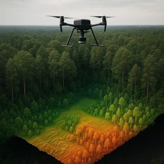
Environmental Monitoring: Keeping an Eye on Our Planet
Chances are, you’ve heard about climate change and the alarming rate at which our ecosystems are changing. Lidar technology has become indispensable for environmental scientists who monitor everything from coastal erosion to habitat destruction.
Mapping Coastlines
Why take a boat out into rough seas when Lidar can give you precise measurements of coastlines from the air? Researchers are utilizing airborne Lidar to track changes in shorelines, ensuring that we have the data necessary to protect vulnerable habitats. It’s like giving Mother Earth a check-up — and who wouldn’t want to do that?
Autonomous Vehicles: The Future is Now
Now, let’s get into the world of self-driving cars. You might picture them whizzing around town, but the truth is far more fascinating. For autonomous vehicles to navigate complex environments, they need brains and eyes to do it safely. Enter Lidar, which acts like a 360-degree vision, allowing the car to perceive its surroundings in real time.
Lidar vs. Cameras
I’ll be honest: I used to think cameras were enough for an autonomous vehicle to function. But after seeing Lidar in action, I’ve changed my tune. Lidar can operate in low-light conditions and create detailed 3D maps that are crucial for split-second decision-making. As the technology matures, it’s reshaping our roads, one laser pulse at a time.
Agriculture: Cultivating Precision Farming
You might not imagine farmers as cutting-edge technologists, but that’s exactly what’s happening thanks to the integration of Lidar tech in agriculture. Farmers are using drones equipped with Lidar to create detailed maps of their fields, allowing for more effective planting, irrigating, and harvesting.
Detailed Crop Assessment
Using Lidar, farmers can determine the health of their crops by evaluating plant height and biomass — encouraging more efficient resource use. It sounds a bit nerdy, but the implications for food security and sustainability are massive. Personally, I think this could revolutionize how we approach farming in an era of climate uncertainty.
Construction: From Ground Up
In the fast-paced world of construction, taking quick and precise measurements can mean the difference between success and expensive errors. Lidar plays a crucial role here, ensuring construction sites are accurately mapped before work begins.
A New Standard of Precision
Builders can scan sites to create as-built models, comparing them against design plans. This technology not only minimizes costly mistakes but also streamlines workflow. If you’ve ever been involved in a construction project, you know the chaos that can ensue without precise information.
A Word on Accessibility: Making Lidar Open Source
Now here’s something you might not expect: Lidar technology isn’t just for big corporations or research institutions anymore. It’s slowly becoming available through open-source platforms, allowing smaller companies and even independent researchers to utilize its power. It’s fascinating to think how democratizing tech can open up more innovative solutions to real-world problems.
FAQ About Lidar Technology
- What exactly is Lidar?
- Lidar stands for Light Detection and Ranging. It uses laser pulses to measure distances and create 3D models of environments.
- How accurate is Lidar?
- Lidar can achieve a vertical accuracy of up to a few centimeters, which is impressive compared to traditional surveying methods.
- What industries use Lidar?
- Lidar is used in various sectors, including forestry, urban planning, archaeology, environmental monitoring, autonomous vehicles, agriculture, and construction.
- Is Lidar data expensive?
- Costs can vary widely based on the scope and technology used, but growing access and open-source options are making it more affordable.
- Can Lidar work in bad weather?
- While Lidar works well in various conditions, heavy rain or fog can affect performance. It’s best utilized in clear conditions for optimal results.
So there you have it. Lidar technology isn’t just some sci-fi fluff; it’s actively changing the way we live and interact with the world around us. I’m not sure if it’ll ever become a household name, but it’s clear that its applications are limitless, and I can’t wait to see how it evolves. Happy scanning!