

Once upon a time in the realm of 3D mapping and surveying, two mighty titans emerged, each armed with its own unique set of capabilities and charms. On one side, we have Lidar, the laser-shooting wizard that can map the world with pinpoint accuracy. On the other, there’s Photogrammetry, the artful conjurer that transforms ordinary photographs into stunning 3D models. So, which one should you choose? Well, it depends on your needs, budget, and maybe even your mood. Let’s delve into the fascinating world of Lidar and Photogrammetry to see which one reigns supreme.
The Basics of Lidar
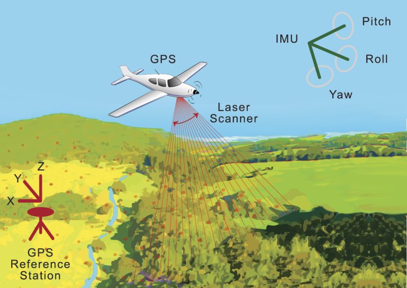
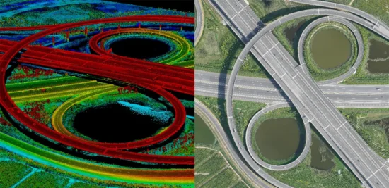
Lidar, short for Light Detection and Ranging, is like the Tony Stark of mapping technologies. It uses laser beams to measure distances and create high-resolution maps of the Earth’s surface. The process is simple yet sophisticated: a Lidar sensor emits laser pulses, which bounce off objects and return to the sensor. By calculating the time it takes for the pulses to return, Lidar can determine the distance to the object with impressive accuracy.
Lidar is often used in autonomous vehicles, architecture, and environmental studies. Its ability to penetrate vegetation makes it a favorite for archaeologists, who use it to uncover hidden ancient ruins. Who knew lasers could be so good at digging up the past?
Advantages of Lidar
- Precision: Lidar provides highly accurate and detailed data, making it ideal for projects that require precision.
- Penetration: It can see through dense vegetation, making it perfect for forestry and archaeological surveys.
- Speed: Lidar can cover large areas quickly, making it efficient for large-scale mapping projects.
Disadvantages of Lidar
- Cost: Lidar equipment and data processing can be expensive, which may not be suitable for all budgets.
- Weather Dependency: Lidar’s effectiveness can be hampered by adverse weather conditions like rain or fog.
The Enchantment of Photogrammetry
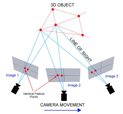
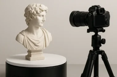
Photogrammetry is like the Sherlock Holmes of mapping. Instead of lasers, it uses photographs taken from multiple angles to reconstruct a 3D model. Imagine being able to transform your holiday snaps into a 3D map of your vacation spot—that’s the magic of photogrammetry. It works by analyzing photographs to identify common points, which are then used to create a 3D representation of the scene.
Photogrammetry is often used in fields like architecture, gaming, and cultural heritage preservation. It’s a favorite among hobbyists and professionals alike, thanks to its accessibility and versatility.
Advantages of Photogrammetry
- Cost-Effective: Unlike Lidar, photogrammetry requires only a good camera and software, making it more budget-friendly.
- Detail: It can capture textures and colors, providing a realistic representation of the mapped area.
- Flexibility: Photogrammetry can be used in a wide range of applications, from small objects to large landscapes.
Disadvantages of Photogrammetry
- Accuracy: While generally accurate, photogrammetry may not match Lidar’s precision, especially in complex environments.
- Data Processing: The process of converting photos to 3D models can be time-consuming and computationally intensive.
Choosing the Right Tool for the Job

So, which technology should you choose? The answer, as with many things in life, is “it depends.” If you’re working on a project that requires high precision and can afford the cost, Lidar might be the way to go. However, if you’re on a budget and need to capture detailed textures and colors, photogrammetry could be the better choice.
Let’s take a closer look at some scenarios where each technology shines:
When to Use Lidar
- Environmental Studies: Lidar’s ability to penetrate vegetation makes it ideal for studying forests and ecosystems.
- Archaeology: Discover hidden sites beneath dense foliage without disturbing the environment.
- Infrastructure Projects: High precision is crucial for designing and maintaining infrastructure like roads and bridges.
When to Use Photogrammetry
- Architecture and Real Estate: Create stunning 3D models of buildings with realistic textures.
- Gaming and VR: Capture detailed environments for immersive gaming and virtual reality experiences.
- Cultural Heritage: Preserve historical sites and artifacts in 3D without the need for expensive equipment.
Theoretical Insights
Now, for the nerdy stuff! Lidar and photogrammetry operate on different scientific principles. Lidar is based on the time-of-flight principle, where the time it takes for a laser pulse to travel to an object and back is used to calculate distance. This method is highly accurate but requires specialized equipment.
Photogrammetry, on the other hand, relies on the principles of triangulation. By capturing multiple images from different angles, it identifies shared points and calculates their positions in 3D space. While this method is more accessible, its accuracy can be affected by factors like lens distortion and image quality.
Combining Forces
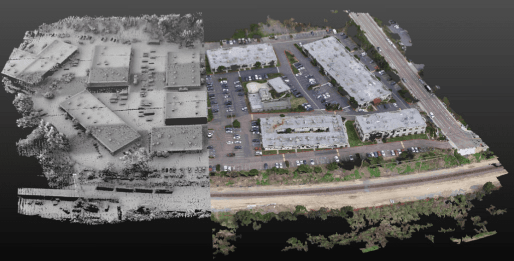
Who says you have to choose one over the other? In some cases, a combination of Lidar and photogrammetry can yield the best results. Lidar can provide accurate topographical data, while photogrammetry adds detailed textures and colors. This hybrid approach is often used in fields like urban planning, where both accuracy and visual detail are important.
Think of it as Batman and Superman teaming up to save the day. While they may have their differences, together, they’re unbeatable!
In the end, whether you choose Lidar or photogrammetry, remember that both technologies have their strengths and weaknesses. The key is to understand your project’s requirements and choose the tool that best meets your needs. And who knows? You might even find that combining both technologies gives you a mapping solution that’s truly out of this world!