
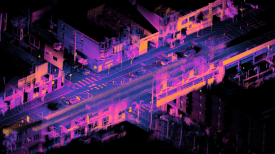
LiDAR, an acronym for Light Detection and Ranging, is a revolutionary remote sensing technology that has dramatically reshaped our understanding of the physical world. By utilizing laser light to measure distances, LiDAR creates precise and detailed three-dimensional (3D) models of the environment. This technology has become indispensable across various industries, from archaeology to autonomous vehicles, and its influence continues to grow.
The Basics of LiDAR Technology
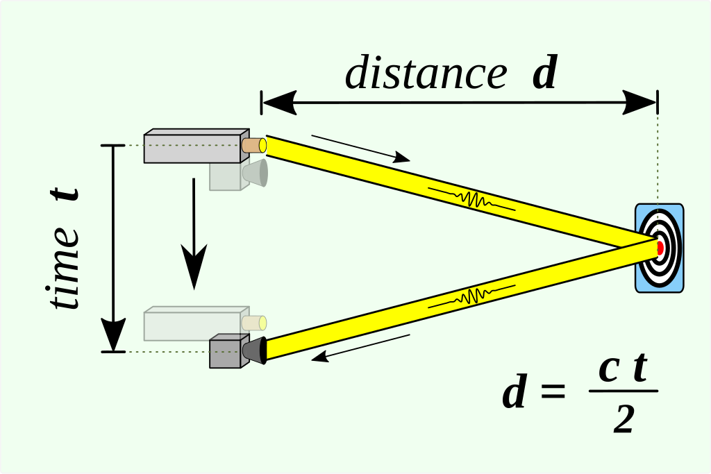
At its core, LiDAR operates on a relatively straightforward principle: a LiDAR sensor emits pulses of laser light, which then bounce back after hitting an object. The time it takes for the light to return to the sensor is recorded, and this data is used to calculate the distance between the sensor and the object. This process, known as the “Time of Flight” (ToF) principle, allows LiDAR to map out the contours of objects and landscapes with incredible precision.
LiDAR systems typically consist of four main components:
- Laser: Emits the light pulses.
- Scanner and Optics: Directs the laser beams across the target area.
- Receiver: Detects the reflected pulses.
- Position and Navigation Systems: Tracks the location and orientation of the sensor, often using GPS.
The precision of LiDAR technology is due to its ability to measure distances to an accuracy of just a few centimeters. This capability is critical for applications requiring detailed mapping, such as urban planning, forestry management, and autonomous vehicle navigation.
How Does LiDAR Work? Breaking Down the Mechanics
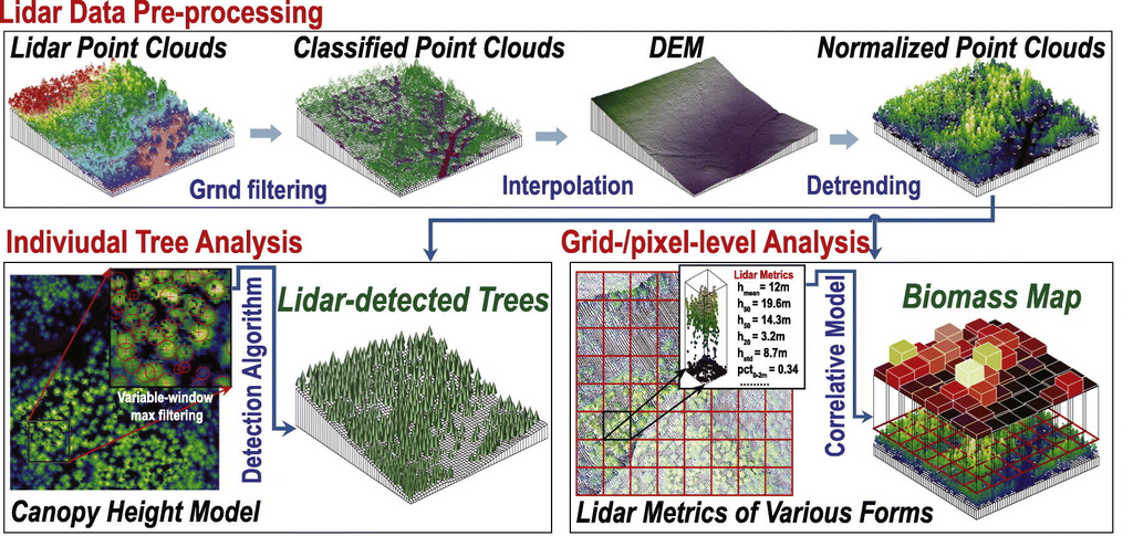
Understanding the mechanics of LiDAR is essential for appreciating its capabilities. The process begins with the emission of laser pulses. A LiDAR system can emit hundreds of thousands of these pulses every second, with some advanced systems reaching up to a million pulses per second. Each pulse travels at the speed of light, reflecting off objects and returning to the sensor almost instantaneously.
Once the laser pulses reflect back to the sensor, the system records the time it took for each pulse to return. By multiplying this time by the speed of light, the system calculates the distance to the object. These distance measurements are then used to create a “point cloud,” which is a collection of data points representing the scanned object’s surface. The point cloud data is processed using advanced algorithms to generate a highly accurate 3D model.
LiDAR can penetrate certain obstacles, such as foliage, allowing it to capture details hidden beneath trees or other obstructions. This capability makes it invaluable for applications like forestry and archaeology.
The accuracy of LiDAR systems can be influenced by various factors, including the wavelength of the laser, the speed of the scanning process, and environmental conditions such as weather or the presence of dust. However, even with these variables, LiDAR remains one of the most precise mapping technologies available.
Applications of LiDAR in Various Fields
LiDAR in Archaeology: Unearthing the Past
Source: Wikimedia
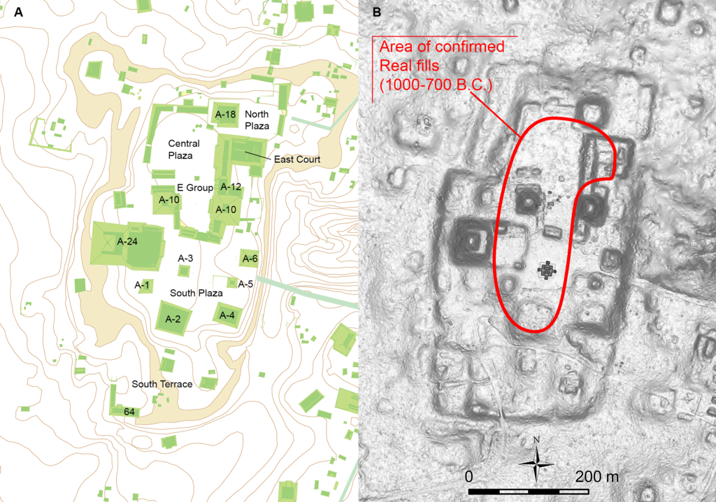
A notable example of LiDAR’s impact on archaeology is its use in the exploration of the Maya civilization in Central America. Dense jungles have long obscured the ruins of this ancient society, making it difficult to map and study. With LiDAR, researchers have been able to uncover vast networks of cities, roads, and agricultural terraces that were previously unknown. These discoveries have significantly altered our understanding of Maya society and its complexity.
LiDAR has become an essential tool in archaeology, offering a non-invasive method to explore and document historical sites. This technology has opened new avenues for research and has led to the discovery of countless previously hidden sites. For more on this application, refer to this in-depth case study on Mayan archaeology.
LiDAR in Mobile Devices: Transforming Smartphones with iPhone and Android

The integration of LiDAR technology into consumer electronics, particularly smartphones, marks a significant leap forward in the accessibility and application of this technology. Apple’s introduction of a LiDAR scanner in its iPhone 12 Pro and later models has brought this advanced technology into the hands of everyday users. The LiDAR scanner on the iPhone enhances augmented reality (AR) experiences, improves photography with better depth-sensing, and enables accurate room scanning for interior design and measurement purposes.
For example, in AR applications, the LiDAR scanner enhances the realism of virtual objects by accurately placing them in a real-world environment. This capability is crucial for applications like gaming, where the interaction between virtual and real-world objects needs to be seamless, and for practical uses like home improvement, where accurate measurements are essential.
On the Android side, while dedicated LiDAR scanners are not as prevalent, several apps utilize ARCore and similar technologies to offer comparable functionalities. These apps allow users to create 3D models of objects, measure spaces, and even perform simple tasks like scanning a room. Although not as precise as the LiDAR on the iPhone, these tools still offer significant utility in everyday scenarios.
The integration of LiDAR in mobile devices has democratized access to this powerful technology, making it available to a broader audience. This accessibility has spurred innovation in app development and has broadened the range of applications that can benefit from LiDAR. For an example of how this technology is being used, visit this overview of AR applications on iPhone.
LiDAR in Autonomous Vehicles: Enhancing Safety and Navigation

LiDAR is a cornerstone technology in the development of autonomous vehicles, providing the detailed environmental awareness needed for safe and reliable navigation. Self-driving cars rely on a suite of sensors, including cameras, radar, and LiDAR, to understand their surroundings and make real-time decisions.
LiDAR’s ability to create precise 3D maps of the environment allows autonomous vehicles to detect obstacles, identify road markings, and navigate complex urban landscapes. Unlike cameras, which can be affected by lighting conditions, or radar, which may struggle with certain materials, LiDAR provides consistent and reliable data under a wide range of conditions.
Companies like Waymo, a leader in autonomous vehicle technology, heavily rely on LiDAR for their self-driving cars. Waymo’s vehicles use LiDAR to create a 360-degree map of their surroundings, which is then used to navigate safely through streets and highways.
LiDAR’s role in autonomous vehicles is critical for ensuring the safety and efficiency of self-driving systems. As the technology continues to improve, it will become an even more integral part of the autonomous driving ecosystem. For more details, check out this deep dive into Waymo’s use of LiDAR.
Environmental Monitoring: Protecting the Planet with Precision
LiDAR technology plays a crucial role in environmental monitoring, providing detailed data that is essential for understanding and managing natural resources. One of the primary uses of LiDAR in this field is the monitoring of deforestation. By providing accurate, high-resolution data on forest structure and biomass, LiDAR helps scientists track changes in forest cover over time, assess the impact of deforestation, and develop strategies for conservation.
Another critical application of LiDAR in environmental monitoring is coastline management. As climate change accelerates sea level rise, understanding and managing coastal erosion becomes increasingly important. LiDAR provides precise measurements of coastline changes, helping to inform mitigation strategies and protect vulnerable communities.
Additionally, LiDAR is used in disaster management, particularly in assessing the damage caused by natural disasters such as earthquakes, landslides, and floods. The ability to quickly and accurately map affected areas allows for more effective response and recovery efforts.
LiDAR in Agriculture: Driving Precision Farming
The agricultural sector has increasingly turned to LiDAR technology to optimize farming practices and improve crop yields. Known as precision farming, this approach involves using detailed data to manage fields more effectively. LiDAR provides accurate topographic maps that help farmers understand the variations in their land, allowing them to optimize planting, irrigation, and harvesting.
LiDAR can also be used to assess crop health by measuring the height and density of crops. This information helps farmers identify areas that may require additional attention, such as those suffering from poor drainage or nutrient deficiencies.
One innovative use of LiDAR in agriculture is in vineyard management.
Vineyards are often located on uneven terrain, making it challenging to ensure consistent crop quality. LiDAR helps vineyard managers map the terrain accurately and manage their vines more effectively, resulting in higher-quality grapes and more efficient use of resources.
The adoption of LiDAR in agriculture is driving a shift towards more sustainable and efficient farming practices. By providing detailed insights into the land and crops, LiDAR helps farmers make more informed decisions that lead to better outcomes. For a closer look at how LiDAR is being used in agriculture, explore this case study on precision farming.
Comparison of LiDAR applications in various industries
| Industry | Application | Impact |
|---|---|---|
| Archaeology | Mapping and discovering ancient sites | Revealed unknown civilizations |
| Mobile Technology | AR applications, 3D scanning | Enhanced user experience in consumer devices |
| Autonomous Vehicles | Real-time object detection, navigation | Improved safety and reliability of self-driving cars |
| Environmental | Monitoring deforestation, coastal erosion | Crucial data for climate change mitigation |
| Agriculture | Precision farming, crop health analysis | Increased efficiency and yield in farming |
LiDAR’s versatility makes it a critical technology in many modern applications, from ensuring the safety of autonomous vehicles to aiding in the fight against climate change.
LiDAR and the Future: What Lies Ahead?

As LiDAR technology continues to advance, its potential applications are expanding rapidly. Several trends are shaping the future of LiDAR, including the miniaturization of sensors, improvements in data processing, and the integration of LiDAR with other technologies like artificial intelligence (AI) and machine learning (ML).
One of the most significant developments is the reduction in size and cost of LiDAR sensors. Traditionally, LiDAR systems were bulky and expensive, limiting their use to specialized applications. However, recent advancements have led to the development of smaller, more affordable LiDAR sensors that can be integrated into a wider range of devices, including drones, robots, and even smartphones.
In parallel, improvements in data processing are enhancing the accuracy and speed of LiDAR-generated models. Advanced algorithms are now capable of processing vast amounts of data in real-time, making it possible to use LiDAR in dynamic environments, such as moving vehicles or live disaster zones.
AI and ML are also playing a growing role in LiDAR technology. These technologies can analyze LiDAR data to identify patterns, detect anomalies, and make predictions. For example, in autonomous vehicles, AI algorithms can interpret LiDAR data to make split-second decisions, improving the safety and reliability of self-driving systems.
The future of LiDAR is bright, with advancements in technology making it more accessible, powerful, and versatile. As the technology continues to evolve, it will unlock new possibilities across a wide range of industries. For an in-depth analysis of the future of LiDAR, check out this market report.